
|
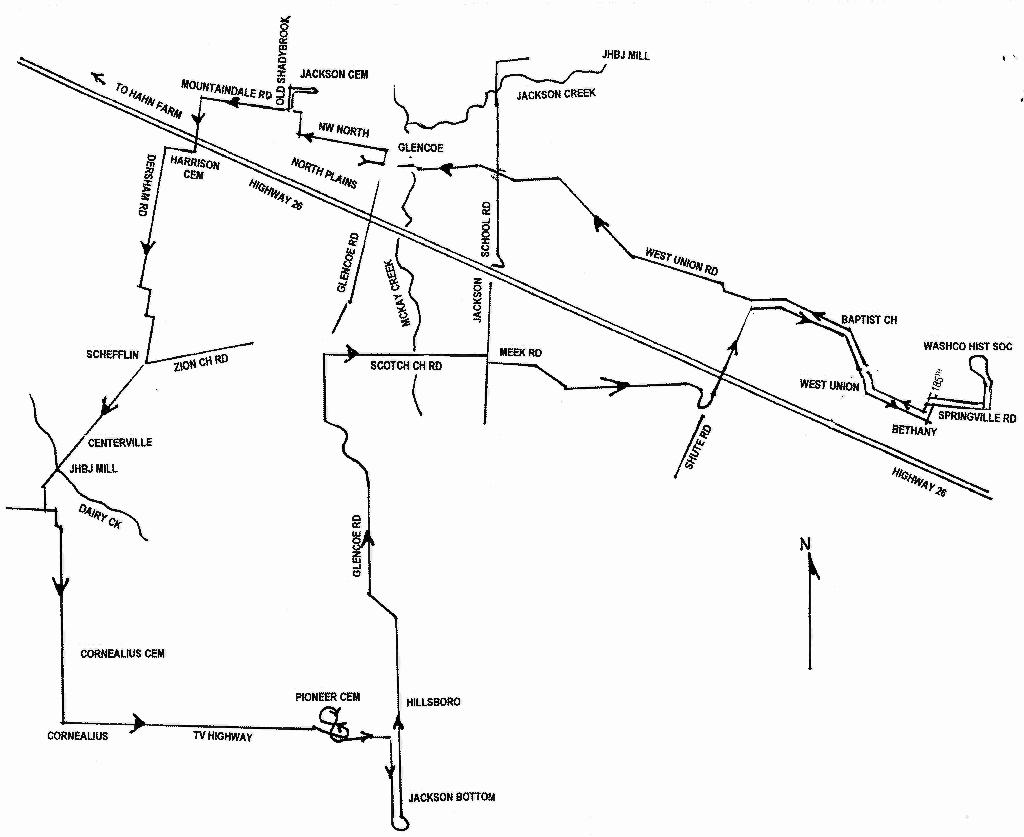
Our group looked much like that of a pioneer wagon train as we left North Plains Community Center. John C. Jackson headed the caravan taking with him about 15 others in a large van they rented for the occasion. Following was Judy Goldman a local historian and genealogist who graciously volunteered her services for the tour. Many others opted to follow in their own vehicles.
Leaving the North Plains Community center we turned left onto Hillcrest to the intersection. Old Glencoe lies to the right of the intersection. This was part of the Donation Land Claim (DLC) of Charles and Letitia Mackay, grandparents of Maria Brooks who married John Wesley Jackson. {John Wesley Jackson was the grandfather of John C. Jackson.} Glencoe, founded by Charles Mackay, was a thriving trading center until 1911 when the United Railway bypassed it in favor of North Plains, a half-mile to the west. One building of notable interest was the pre-1890 Blacksmith Shop. This blacksmith shop in Glencoe belonged to Charley Walters and was the last operating business after the community moved up the hill to be near the railroad line and was renamed North Plains.
A note on Donation Land Claims (DLC): The provisional government set up its unilateral land system under the Organic Law and the United States affirmed it two years after the territory was established. The Donation Land Claim Act of 1850 provided 320 acres of land to a male over 18 and added another 320 for a wife. Her land was held in her name which gave woman's rights an early boost and was the reason Ulysses Jackson had to buy my farm twice (he failed to get the wife's agreement the first time). In five years two and half million acres were distributed to 7000 claimants.
At the intersection we turned left on N. W. North Street, passing the south end of John Johnston and Ulysses Jackson's DLC on the right to a right turn on Old Shadybrook Road. About a quarter mile on the right is the lane leading to the Jackson family cemetery. Ulysses Jackson and many of the Dobbins are buried in this cemetery. Melvin Van Domelen spoke of the Dobbin family connection to the Jackson family. He and his cousin, John Crocker, care for the cemetery. As the town is moving out, fears are for the future preservation the Jackson property and cemetery.
|
|

|

|

|
Returning on Old Shadybrook Road turning left and then right passing the Horatio Nelson Calder DLC. The Callers and Mackays were Canadian mixed-bloods who came in 1841 to strengthen the British claim to everything north of the Columbia River. They came to the north Tualatin Plains instead and became U. S. Citizens.
Following Mountaindale Road west to the first intersection we turned left to cross Highway 26. About eight miles west on 26 was the initial land claim of the Miller family that was relinquished when they moved to Woodland, Washington. Turning left at the stop sign onto Dersham Road, we stopped at the Harrison Cemetery where a number of Mackays and Johnstons are buried. The Harrison DLC land became part of Ulysses Jackson's large holding that passed to the Dersham family when his daughter Lydia married David Dersham. To the west across the fields can be seen a tree line marking the course of Dairy Creek. Somewhere out there John Harrison began an early mill which John H. B. Jackson later operated until he moved to a better head of water in the hills to the northeast. Later a long ditch was dug across country to power the Dudley Mill in which John Wesley Jackson inherited an uneasy interest on behalf of his widowed mother.

|
Proceeding south along Dersham Road to the Zion Church Road we turned right through Schefflin and onto the old community of Centerville. Just a bit to the left of the bridge crossing Dairy Creek was the location of John H. B. Jackson's last mill. The account books of that operation now in the collection of cousin, John Crocker, represent a "Doomsday Book" record of the surrounding community. John's brother Ulysses inherited the supervision of the mill after his death in 1869 and soon sold it to a more dedicated operator named Thrullinger. The new operator was dissatisfied with the water head and raised the mill dam a few feet thereby flooding property upstream. The resulting lawsuit was finally taken to the state supreme court and helped establish early water law for Oregon.
Turning left at the intersection of Verboort Road and Cornelius-Schefflin Road to Cornelius passing the Cornelius Methodist Cemetery on the left where a number of the Wilkes family are buried. Turning left again on to Tualatin Valley Highway we continued to the outskirts of Hillsboro. Across the double highway was the Hillsboro Pioneer Cemetery and the graves of the Hyer Jackson Family.
Hyre Jackson was educated and practiced as a lawyer before coming west with his family in 1854. He took a Donation Land Claim on the north plain near his brothers but was more inclined to public service. In time he was elected County Judge and later County Treasurer. Struck suddenly by a heart attack his last words were "the money is in the safe and keys are in my pocket." Hyer's family was not spared another cruel tragedy when their despondent daughter committed suicide by swallowing ground glass and strychnine. A son Preston served during the Civil War as a volunteer guarding the border against Indians.

|
Heading towards Hillsboro we turned right on 1st Street, crossed the railroad tracks past a stone wall enclosing the water treatment plant. To the left is Jackson Bottom Wetlands Preserve, a marshy, tranquil wildlife sanctuary now on the former Hyre Jackson property. It was noted that a pair of Bald Eagles had successfully raised a chick and had stayed in the refuge for two winters. Thousands of visitors, school groups and bird watchers visit this preserve yearly. Covered viewing stations are opened at the north end of the preserve. The structure is a short walk along the trail. In 1989 a master plan was drafted "calling for enhancement of Jackson Bottom to increase the diversity of wildlife, improve water quality as it affects the nearby Tualatin River, provide research and educational experiences and create passive recreational opportunities." ("Hillsboro Highlights 2000" Hillsboro Chamber of Commerce Official Visitors & Residents Guide, p. 9).

|
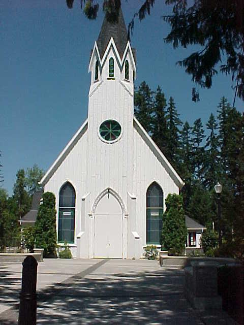
Back on 1st Street from Jackson Bottoms through Hillsboro to N. W. Glencoe Road, about 4.5 miles we turned right on Old Scotch Church Road pausing to admire the beautiful old Presbyterian Church where the John Wesley Jackson family and descendants rest among many other early pioneers. Continuing east and jogging right and then left to Meek Road. Joseph Meek whose DLC lay to the north was one of the enterprising young men that David E. Jackson and his partners Jedediah Smith and Bill Sublette brought into the Rocky Mountain beaver hunt in 1829.
Continuing on a gravel road to the intersection with Shute Road we turned left onto the overpass across Highway 26. To the east as you cross the highway are the famous Five Oaks and new pavilion, which mark one of Washington County's most significant historical sites. For hundreds of years it was a gathering place where community business was conducted, as well as camp meetings and picnics. It served as a meeting place for the Atfalati Band of the Kalapuya Tribe and in the 1830's was a rendezvous for the mountain men and trappers to sell their pelts. County court once met under the oaks and farmers, hauling their produce to Portland, used the area as a resting stop. In 1855, celebrants firing their rifles punctuated daylong Fourth of July festivities. A cannon was fired at the end of the day in final salute. It exploded but no one was injured. Three small trees have replaced those which were downed by storms early in the last century.
|
A right onto West Union Road took us to the West Union Baptist Church at the top of the hill, which we passed by and returned to at the end of the tour. This is the oldest Baptist Church west of the Rockies and is the resting place of John Henderson Brake Jackson and his family. One notable grave is that of his son John S. Jackson who lost his arm in an accident. Never the less he hunted by tucking the stock of his shotgun under the stump of his arm. That was good enough to exercise authority in the tough mill town of North Plains where he patrolled the street as Constable. Other pioneers of the famous 1843 "Great Migration" are also buried here as well as two firm friends from the mountain man era also introduced by Smith, Jackson and Sublette. George Ebberts and Caleb Wilkins learned to protect each other's backs in the Blackfoot County and never separated. Like Joe Meek, they brought Indian wives when they became the first settlers on the north plains.

|

|
We continued east on West Union Road to the growing suburban community that was once tiny Bethany, left on 185th and right on Springville Road, {The pioneers hauled their grain over this road in the early days.}then left to the entrance of the Portland Community College's Rock Creek campus. Donna Bandeen met us here with refreshments of lemonade and cookies. A welcomed treat! We visited the Washington County Historical Society where the staff had prepared a few items of interest relating to the Jackson family and enjoyed their wonderful displays.

|
From the Washington County Historical Society we backtracked to West Union Road stopping at the Baptist Church to view the gravesite of John H. B. Jackson. (see above)
We then continued on West Union Road several miles to Jackson School Road. At this crossing stood the little county school that gives that road its name. John H. B. Jackson donated land for this school. John C. Jackson attended school there as did Florence Hedden's sister.
The John Wesley Jackson farm lay to the southwest and land belonging to John H. B. Jackson to the northeast. The former steward of Fort Vancouver initially claimed the John H. B. property. Facing the freedom of U. S. Citizenship, Englishman William Burris became religiously deranged and killed his wife and children before they could be overtaken by sin. The community lacked any facility for dealing with the insane and Burris had to be locked up in the jail until they figured out what to do with him. He resolved the problem by expiring.
Ulysses Jackson was not entirely pleased by his acquisition of the property that became the home of his son John Wesley. Part of that place belonged to the Red River colonist family of Ale Burston, who later sold it to another party. The Donation Land Law awarded 320 acres to a single man and 640 to a married couple with the wife enjoying an interest in half of the land. After Jackson acquired the property, Janette Burston claimed that she had not been consulted about the initial sale and brought suit. After a number of trials Jackson was privileged to get to pay for the land a second time.
Just north is the house of Clyde and Etta Lincoln. The road leading that way crosses an inconsequential creek and eventually comes to the rock quarry that has almost eaten up Jackson Falls. That was the site of John H. B. Jackson's second combination grist and sawmill. He took over the improvements made by Charles Mackay with iron work brought from the lower end of Puget Sound and had a rewarding operation going. In 1857 rains brought on high water and the mill dam was threatened. Two valley men, one of whom was Columbus Wilkes, came to make a grist and scoffed at John's warning that the dam might go. They went to sleep in the mill and their bodies along with John's millwork were found scattered all along Jackson Creek. The recovered millstone is now part of the Historical Society collection. After John's expectations were swept away, he moved to the Centerville mill location.
This concluded the tour of the north Tualatin Plains. It is pioneer country that remained pretty much as it had been until mid-twentieth century when suburban expansion from Portland spread over the West Hills. In the 1970's and 1980's the electronics age came to the valley which started to be described as Oregon's Silicon Forest. Now factories of the new age have engrossed many of the old Donation Land Claims and this old (by western standards) country is very much in the new century.
Not on the tour, but close by is Jackson Falls on Jackson Creek (see tour map). Jackson Creek is a tributary of McKay Creek and is about eight miles north of Hillsboro. The falls of this stream are known as Jackson Falls. These features were named for John B. Jackson, a pioneer settler who took up a donation land claim nearby.

|

|